Alerts
Arctic Patrols and Greenland Tensions: A CIRAS Alert on Modern Arctic Movement
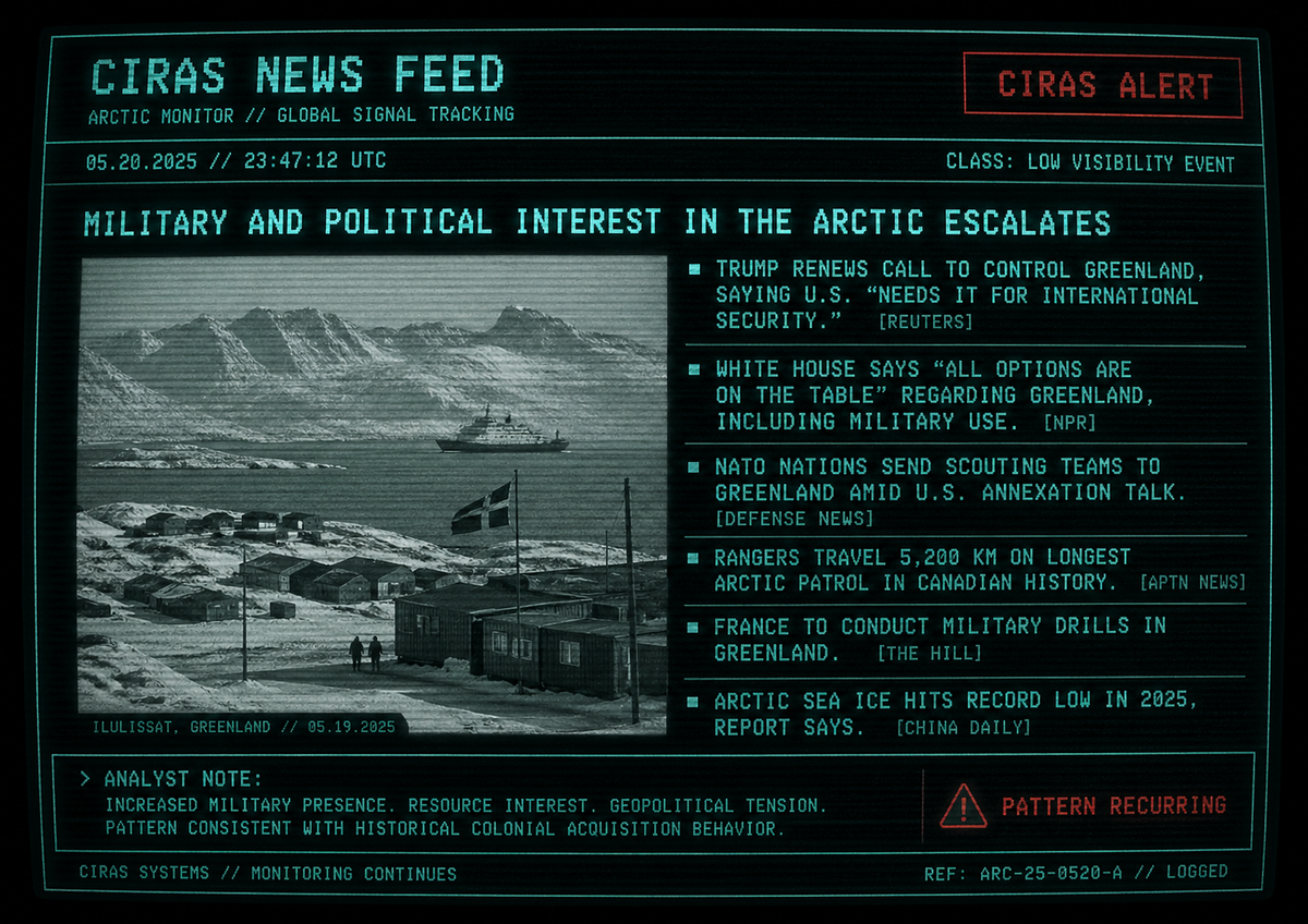
Arctic patrols are expanding, and global interest in Greenland is rising. As movement across the North becomes more structured and monitored, CIRAS identifies a recurring pattern — one that mirrors historical activity in the Frobisher Bay region.
⚠ CIRAS ALERT — FIELD PATTERN DETECTED
↳ SIGNAL CORRELATION — ARCTIC MOVEMENT
> CLASSIFICATION:
LOW VISIBILITY EVENT
> REGION:
ARCTIC / SUBARCTIC
CORRIDORS
> STATUS:
ACTIVE
“Movement across the land has never stopped. Only the reason changes.”
Recent field reports confirm extended patrol activity across northern territories, with units traveling over 5,000 km through Arctic terrain.
↳ “5,200 kilometre mission… across the High Arctic”
These movements are not isolated.
Multinational Arctic operations have expanded, integrating land, air, and surveillance coordination across multiple regions.
↳ Operations designed to “detect threats early” and maintain presence
Parallel deployments across Greenland and surrounding territories indicate increasing strategic interest in northern control zones.
↳ NATO mission launched to “increase presence in the Arctic”
***
Historical entries recovered from the Frobisher Bay region describe similar patterns:
• External requests for guided movement across unfamiliar terrain
• Supply distribution dictating settlement behavior
• Authority figures leveraging access to mobility and survival resources
These patterns were once localized.
They are no longer.
***
Modern Arctic operations now integrate:
• Long-range patrol routes replacing localized navigation systems
• Persistent surveillance across land, air, and maritime domains
• Coordinated multinational presence under unified command structures
The land has not changed.
The methods have.
INTERPRETATION:
Movement is being standardized.
Access is being negotiated.
Presence is being reinforced.
ANOMALY:
Historical records indicate resistance to imposed movement patterns.
Current models show adaptation.
Cause of transition unknown.
RELATED QUESTIONS — FROBISHER BAY / IQALUIT CONTEXT
↳ CONTEXT BRIEF — HISTORICAL LOCATION DATA
Q: Is Frobisher Bay the same place as Iqaluit?
A: Yes. Frobisher Bay was the former name used by qallunaat (outsiders) for the settlement now known as Iqaluit. The name referred to both the bay and the growing settlement along its shore.
Q: Why was the name changed from Frobisher Bay to Iqaluit?
A: The name was officially changed in 1987 to reflect Inuit language and identity. “Iqaluit” means “place of many fish” in Inuktitut, restoring a name rooted in the land rather than colonial exploration history.
Q: Who was Frobisher Bay named after?
A: The name came from English explorer Martin Frobisher, who arrived in the region in the 16th century. Like many Arctic place names, it reflected European exploration rather than Indigenous presence.
Q: Why was Frobisher Bay important in the 20th century?
A: During World War II and the Cold War, the area became a major strategic location. The United States and Canada built an airbase there as part of northern defense and transatlantic flight routes. This led to increased infrastructure, military presence, and permanent settlement.
Q: How did this affect Inuit communities?
A: The expansion of military and government infrastructure contributed to Inuit being encouraged or pressured to settle permanently near Frobisher Bay. Traditional seasonal movement patterns began shifting toward centralized communities.
Q: Why do older records still use the name Frobisher Bay?
A: Historical documents, military logs, and early government records continue to use the name because it was official at the time. Many archival materials, including field reports and patrol logs, have not been updated to reflect modern naming.
***
Q: Why does CIRAS reference both names?
A: Location naming inconsistencies appear across recovered records.
Dual-reference improves alignment between historical logs and modern mapping systems.
STATUS: DESIGNATION VARIANCE CONFIRMED
RELATED QUESTIONS — ARCTIC OPERATIONS & CONTROL
↳ CONTEXT BRIEF — PUBLIC RECORD (FILTERED)
Q: Why are Arctic patrols getting longer and more frequent?
A: Recent patrols, including routes exceeding 5,000 km, are part of efforts to monitor sovereignty, climate changes, and increased activity in the Arctic. These patrols often combine modern technology with Indigenous land knowledge to navigate extreme conditions.
Q: What is driving increased military and political interest in Greenland?
A: Greenland has become strategically important due to its location, natural resources, and access to Arctic shipping routes. Governments have expressed interest in strengthening presence there for both security and economic reasons.
Q: Are these actions considered defensive or expansionist?
A: Official statements describe Arctic operations as defensive and necessary for national security. However, analysts and international observers debate whether increased presence and infrastructure signal long-term strategic control.
Q: How does this relate to historical Arctic activity?
A: Historically, Arctic movement was guided by survival, seasonal patterns, and local knowledge. In modern contexts, movement is increasingly influenced by logistics, infrastructure, and geopolitical strategy.
Q: Are Indigenous communities still involved in Arctic patrols?
A: Yes. Canadian Rangers and other Arctic units often rely on Indigenous expertise and local knowledge, particularly for navigation, survival, and environmental awareness.
***
Q: Why does CIRAS flag these developments?
A: Pattern alignment detected between historical field records and modern operational behavior.
Movement, access, and presence continue to follow similar structural models across time.
STATUS: OBSERVATION ONGOING