> SEARCH-FACING TITLE: History of Lake Abitibi, Ontario and Quebec:
The Landscape Before the Story
History of Lake Abitibi, Ontario and Quebec: The Landscape Before the Story
> DOSSIER SUMMARY:
Lake Abitibi is not introduced as haunted.
It is introduced as divided, shallow, old, island-filled, and hydrologically strange enough that memory has places to hide.
Before treaty lines, trading posts, dams, rail corridors, timber extraction, or settlement records enter the file,
Lake Abitibi must first be understood as terrain.
The first record is not an event.
It is a surface.
A shallow border lake.
A broken shoreline.
A body of water divided by Ontario and Quebec, but not obedient to either.
A lake thick with islands, narrows, wetlands, and northbound drainage toward James Bay.
Terrain is not background. Terrain is the first witness.
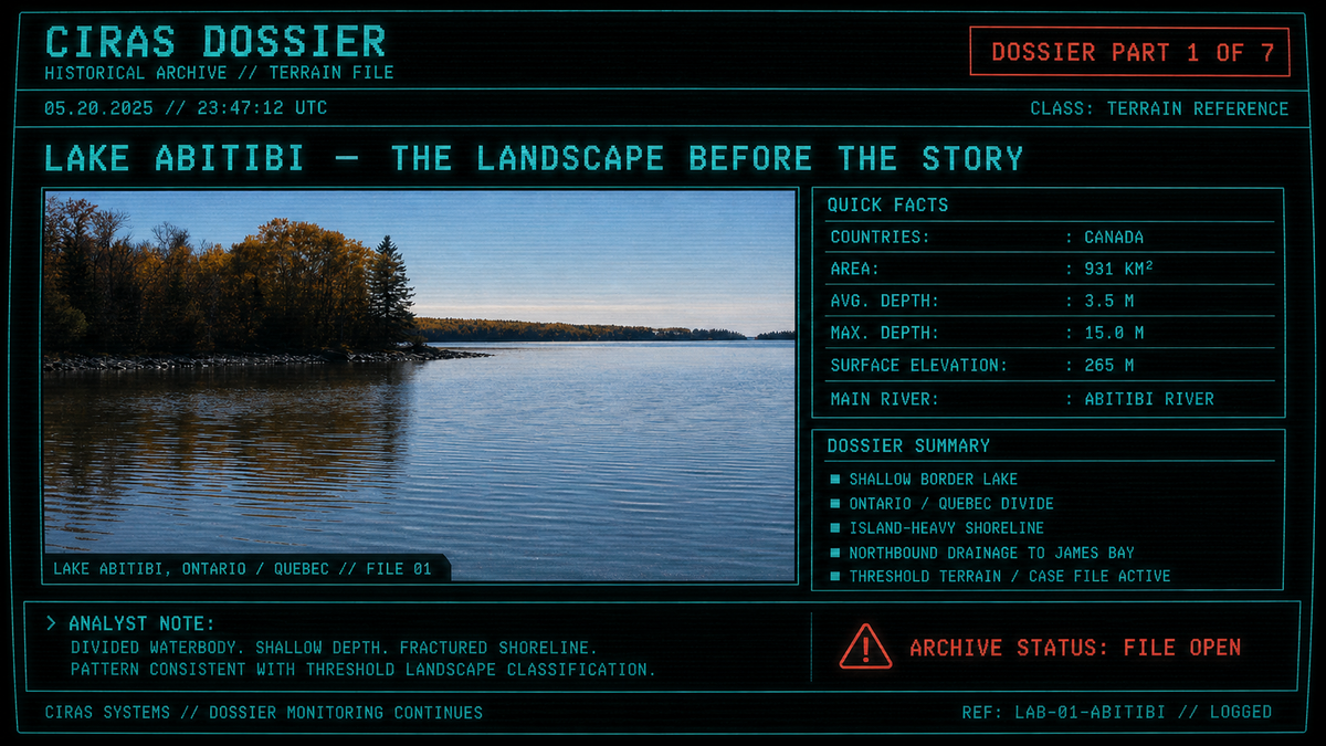
> VISUAL TERRAIN REFERENCE ATTACHED
Terrain reference: Lake Abitibi, a shallow border lake between Ontario and Quebec, draining north toward James Bay.
> SOURCE MATERIAL:
Natural Resources Canada — Canadian Geographical Names Database: Lake Abitibi
Ontario Parks — Lake Abitibi Islands Provincial Park Management Statement
Ontario Ministry of Natural Resources — Ecosystems of Ontario: Ecozones and Ecoregions
Encyclopaedia Britannica — Abitibi River
> CASE FILE BOUNDARY:
This first dossier is limited by design.
Case File 01 does not examine Treaty No. 9, colonial trading posts, hydroelectric flooding,
railway construction, timber extraction, mining, or later settlement history.
Those records remain assigned to subsequent files in this series.
This file concerns the landscape before the story: where Lake Abitibi sits, how its water is shaped,
how the shoreline breaks apart, how the lake drains, and why this physical geography matters before
the historical archive begins naming specific human events.
> GEOGRAPHIC IDENTIFIERS:
Region: Northeastern Ontario / Northwestern Quebec
Waterbody: Lake Abitibi
Classification: Large shallow border lake
Surface area: Approximately 931 square kilometres
Surface elevation: Approximately 265 metres above sea level
Connected drainage: Abitibi River → Moose River → James Bay
Archive status: Terrain file active
> BORDER LAKE RECORD:
Lake Abitibi lies across the Ontario–Quebec border in northeastern Canada.
Standard geographical references describe it as a large, shallow lake positioned between two provinces
while remaining one connected waterbody.
[CIRAS FLAG]: Position relevant.
Lake Abitibi is not simply “in the north.” It is a cross-border lake, split by provincial jurisdiction
while remaining hydrologically whole.
The official Canadian Geographical Names Database lists
Lake Abitibi as an official geographical name
of Algonquin linguistic origin and anchors it in the Abitibi-Ouest / Ontario setting.
In plain terms:
The map divides it.
The water does not.
> TERRAIN FLAG:
One lake.
Two provinces.
Multiple basins.
No clean edge.
> WATER-SHAPE ANALYSIS:
Lake Abitibi is divided politically by the Ontario–Quebec border, but its physical shape is fractured as well.
Ontario protected-area documentation notes that the Ontario portion of Lake Abitibi is naturally separated
into northwest and southeast sections by
The Narrows, a channel near McDougal Point and Deer Island.
That detail is foundational.
The lake is not a clean oval on a map. It is segmented by channels, islands, bays, and interrupted passages.
The Narrows gives the lake a second kind of division: not legal, but physical.
The first instability in the file is geographical.
> ISLAND FIELD:
The strongest visual fact in the Lake Abitibi record is the island field.
Ontario’s Lake Abitibi Islands Provincial Park incorporates
786 islands on the Ontario side alone.
These range from tiny shoals and islets to larger islands of up to approximately 550 hectares.
The same provincial documentation identifies the islands as habitat for waterfowl, osprey, bald eagles,
cormorants, great blue herons, and fish spawning areas.
This means Lake Abitibi should not be imagined as a single open sheet of water.
It is better understood as a broken surface:
• Shoals
• Rock domes
• Wave-washed outcrops
• Sediment-capped islands
• Boulder-rimmed shores
• Interrupted landing edges
Movement across such a lake is never neutral.
Routes must be chosen.
Sightlines are blocked.
Weather changes the water.
Islands repeat themselves.
A shoreline can look close and remain unreachable.
> FIELD INTERPRETATION:
Island-heavy landscapes produce navigational uncertainty.
They complicate distance, visibility, memory, and return.
The archive classifies this as historically relevant terrain behavior, not anomalous activity.
> SHALLOW WATER RECORD:
Lake Abitibi is repeatedly described in public geographical and environmental sources as shallow.
Ontario’s ecoregion material places Lake Abitibi among the large shallow lakes of the Lake Abitibi Ecoregion.
Secondary limnological sources commonly list its mean depth at only a few metres, though exact depth figures
should be treated cautiously unless tied to a formal bathymetric survey.
For this file, the important point is not a single depth number.
The important point is the lake’s character.
Shallow lakes behave differently than deep lakes.
Wind can move through them quickly.
Shoreline wetlands matter more.
Sediment, submerged edges, and changing water conditions can alter how the surface appears from one hour to the next.
A shallow lake does not hide depth in the usual way.
It hides edges.
> NORTHBOUND DRAINAGE:
Lake Abitibi is not a sealed body of water.
Its outlet is the
Abitibi River, which runs generally northward for roughly 547 kilometres
before joining the Moose River and emptying into James Bay.
That hydrology matters because it places Lake Abitibi inside a larger moving system.
The lake is part of a drainage path that pulls water north, away from the Great Lakes world and toward
the James Bay / Hudson Bay watershed.
This is where the landscape begins to feel like a threshold without needing fictional treatment.
Water does not simply sit here.
It leaves.
It travels north.
It enters another basin.
> DRAINAGE DIRECTION LOGGED:
Surface memory not contained.
> HEIGHT OF LAND / WATERSHED THRESHOLD:
The wider Lake Abitibi region sits close to one of the most important geographical ideas in northern
Ontario and Quebec: the watershed divide often referred to as the
Height of Land.
Ontario’s ecoregion synthesis notes that most of the Lake Abitibi Ecoregion lies within the Hudson Bay
watershed, while the southwestern portion falls within the Great Lakes watershed.
In other words, this region sits near a drainage logic that decides whether water moves north toward
James Bay or southwest toward the Great Lakes system.
That divide is not just a map feature.
It shaped routes, travel, future development, and later political and economic decisions.
For Case File 01, the meaning is simpler and older:
Lake Abitibi belongs to a landscape where direction matters.
> CLAY BELT SURFACE:
The land around Lake Abitibi is not best imagined as bare northern rock surrounding a single lake.
Ontario’s ecoregion documentation places the northeastern part of the region within the Clay Belt,
with deep glaciolacustrine sediments linked to former post-glacial Lake Barlow-Ojibway.
The Lake Abitibi Islands documentation gives a local version of that same physical history:
glaciolacustrine clays and silts, laid down in glacial lakes Ojibway and Barlow, form part of the
Great Clay Belt extending from west of Timmins into Quebec.
In the same documentation, clay and lake dominate the mapped surface so strongly that,
from the south shore northward, the ratio of clay and lake to bedrock outcrop is described as roughly 20:1.
[CIRAS FLAG]: Terrain composition relevant.
The landscape is not only water and stone.
It is clay blanket, organic low ground, wet edges, subdued relief, peat-rich pockets,
and interrupted firm ground.
A person crossing this terrain would not experience a clean boundary between land and water.
They would experience transition:
Shore into marsh.
Marsh into island.
Island into shoal.
Shoal into open lake.
Open lake into narrows.
> WETLANDS / BOREAL EDGE:
The Lake Abitibi Ecoregion falls within the boreal forest region.
Ontario’s ecoregion material identifies black spruce, white spruce, balsam fir, jack pine,
tamarack, white birch, trembling aspen, and balsam poplar among its main forest species.
Nearby protected-area and island records also point to wetland and shoreline habitats:
marshes, fens, bogs, conifer swamps, island nesting areas, fish spawning grounds,
and bird staging habitat.
This is not empty country.
It is layered, wet, loud with seasonal life, and difficult to simplify.
Birds gather.
Fish spawn.
Water rises against stone.
Clay holds impressions.
Islands break the horizon into pieces.
Historically, those conditions would have shaped movement before any later written record tried
to explain the region.
They would have affected where people could land, where they could travel, what they could see,
and what the landscape allowed them to remember accurately.
> CIRAS INTERPRETIVE NOTE:
A landscape does not need to be supernatural to become unstable in memory.
Shallow water, island clutter, wetlands, borderlines, and watershed thresholds are enough.
> HISTORICAL WEIGHT:
The history of Lake Abitibi, Ontario and Quebec, does not begin with a single dramatic incident.
It begins with geography.
A shallow lake across a provincial border.
A lake whose Ontario side alone contains hundreds of islands.
A lake divided by narrows.
A lake draining north into the Abitibi River, the Moose River, and James Bay.
A lake set within the Clay Belt and near the logic of a major watershed divide.
Before later case files introduce treaty boundaries, trade corridors, industrial water control,
railways, timber, and extraction, Case File 01 establishes the older fact:
Lake Abitibi was already a threshold landscape.
Not haunted.
Not yet.
Only divided, shallow, old, and physically complex enough that any archive built around it must begin
with the surface of the water.
> CLOSING SUMMARY:
The first fact about Lake Abitibi is not what happened on it.
The first fact is what it is.
A shallow divided lake on a northbound watershed does not behave like blank scenery.
It behaves like threshold ground.
> STATUS:
CASE FILE 01 COMPLETE — TERRAIN RECORD ACTIVE
> NEXT FILE QUEUED:
CASE FILE 02 OF 07 — HALFWAY WATER AND DEEP TIME
> ARCHIVE WARNING:
Treaty records, colonial trade routes, hydroelectric alteration, railway corridors, and extraction logs remain sealed for subsequent case files.